If you’ve ever bought land or are in the process of looking, you might have heard of a plat map. This kind of map is a great way to keep all of your property’s features and information in one place, and the best part is they’re easy to find.
With this in your tool belt, you can locate important information about your property easily, which makes learning what a plat map is and how to read one a good skill to have.
What Is A Plat Map?
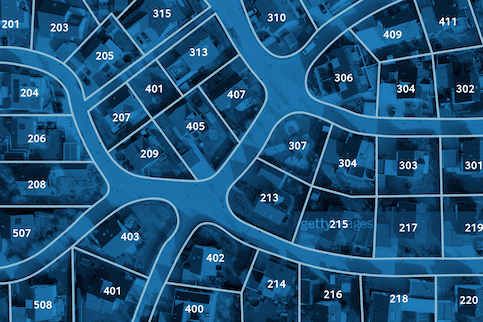
When buying a home or land, you will likely receive a plat map from your title company when you move in. It’ll look like any other kind of map, except its main focus is to include details of the property and show a high-level view of the area and its features. This means the map will include things like property lines, lot dimensions, easements, flood zones or utility lines.
Types Of Plat Maps
There are many different kinds of plat maps and which one works best for you will depend on what kind of property you’re buying or updating. Here are common plat maps you might receive when buying property:
- Plat of a subdivision: This kind of plat will show an entire subdivision, its legal borders and individual plots that are within property lines.
- Amending plat: If you make updates to a property, you also need to make the updates to your plat map. An amending plat map is the process of taking an existing plat map and updating it to match the current state of the property.
- Vacating plat: This is the process of legally canceling an existing plat map.
- Short plat: A short plat is used when land is being divided into typically no more than 4 separate plots.
- Plat of consolidation: Opposite of a short plat, a plat of consolidation is used when several pieces of land are being combined into one.
See What You Qualify For

Buy A Home
Discover mortgage options that fit your unique financial needs.

Refinance
Refinance your mortgage to have more money for what matters.

Tap Into Equity
Use your home’s equity and unlock cash to achieve your goals.
What’s The Difference Between A Plot Map Vs. A Plat Map?
A plat map typically surveys a large piece of land and how it’s divided into different lots. A plot map is going to be specific to an individual plot of land. Since plot maps highlight one lot, you might receive a plot map instead of a plat if you’re buying a home.
Why Do You Need A Plat Map?
You can use your plat map for many different reasons. Maybe you’re feuding over property lines with a neighbor, trying to figure out how much sod to grab at the nursery, or you want to make sure you aren’t digging into utility lines when landscaping.
Even if you don’t have a current need for a plat map, it’s still a great resource to keep in your back pocket especially if you are selling or buying a home. Plat maps have useful information that any buyer would want to know, and any seller would want to include in listing descriptions, like measurements or flood zones.
How To Read A Plat Map
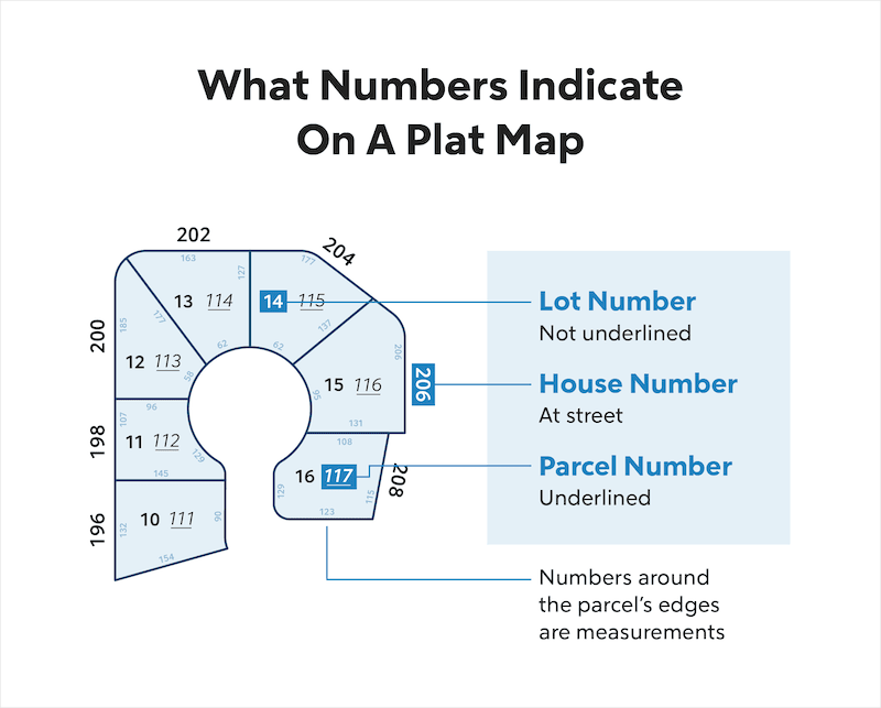
Each plot of land on a plat map has a lot number in the center, surrounded by property lines. The map also includes the measurements of each plot around the edges of the parcel and indicates any easements under the lot number. The plat map should include a legend to help make reading the map easier.
At first glance, a plat map seems like countless numbers and lines to decipher which can be overwhelming. But once you know what they mean, you’ll be able to find the right information easily. Here are some numbers and features of a plat map and where you would find them:
- Lot number: The lot number is usually written inside the properties boundaries near the center and is not underlined.
- House number: Your house number can be found outside the borders of your property by the street.
- Parcel number: Parcel numbers are typically underlined and found within the parcels borders.
- Measurements: These are found around the edge of the lot to show the area of the land.
- Easements: Easements indicate which part of your property that the city or private companies have the rights to. Like other features on the map, these will be sectioned off and labeled as easement.
How To Get A Plat Map Of Your Property
- Contact your local government office or check their website.
- Reach out to your title company and request a copy.
- Go through the paperwork you received when you purchased the home.
Plat maps are public records so they can be easy to find if you weren’t initially given one by a title company
Plat Map FAQs
Some commonly asked questions about plat maps.
What’s the difference between a plat map and a survey map?
A survey map is similar to a plot map, in that it shows an individual property rather than multiple ones like on a plat map. The difference is that these maps can include dimensions of structures on the land, like homes, pools or fences.
Survey maps are also not legally required and are done for the property owner’s personal use.
Are plat map measurements accurate?
If you’re looking at a larger tract of land, plat maps are accurate enough to determine property owners and borders but not exact measurements. For more accurate measurements, consider hiring a land surveyor, who will easily determine accurate measurements.
The Bottom Line
Plat maps are a great resource to have as a homeowner because they provide you with useful information about your property you may need in the future. Make sure to hang onto a copy or look into investing in one.
Along with your plat map, you could also consider learning more about property surveys, opening up your options when it comes to how detailed you want your property knowledge to be.


Morgan Chaperon
Morgan Chaperon is a freelance writer and Michigan State University graduate. She holds a degree in English and history and enjoys reading, writing and going on walks.